


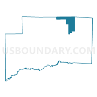
IRISHTOWN 1 Voting District, Clinton County, Illinois
About
Outline

Summary
| Unique Area Identifier | 564944 |
| Name | IRISHTOWN 1 Voting District |
| County | Clinton County |
| State | Illinois |
| Area (square miles) | 16.26 |
| Land Area (square miles) | 6.85 |
| Water Area (square miles) | 9.42 |
| % of Land Area | 42.10 |
| % of Water Area | 57.90 |
| Latitude of the Internal Point | 38.71358740 |
| Longtitude of the Internal Point | -89.28901940 |
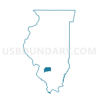
Maps

Graphs
Select a template below for downloading or customizing gragh for IRISHTOWN 1 Voting District, Clinton County, Illinois


Neighbors
Neighoring Voting District (by Name) Neighboring Voting District on the Map
- CLEMENT Voting District, Clinton County, IL
- EAST FORK Voting District, Clinton County, IL
- IRISHTOWN 2 Voting District, Clinton County, IL
- MILLS Voting District, Bond County, IL
- POPE 1 Voting District, Fayette County, IL
- TAMALCO 2 Voting District, Bond County, IL
- WHEATFIELD Voting District, Clinton County, IL
Top 10 Neighboring County Subdivision (by Population) Neighboring County Subdivision on the Map
- Irishtown township, Clinton County, IL (1,167)
- Tamalco township, Bond County, IL (566)
- Mills township, Bond County, IL (552)
- Wheatfield township, Clinton County, IL (478)
- Clement township, Clinton County, IL (475)
- East Fork township, Clinton County, IL (400)
- Pope township, Fayette County, IL (213)
Top 10 Neighboring Place (by Population) Neighboring Place on the Map
Top 10 Neighboring Unified School District (by Population) Neighboring Unified School District on the Map
- Bond County Community Unit School District 2, IL (13,592)
- Carlyle Community Unit School District 1, IL (10,196)
- Patoka Community Unit School District 100, IL (1,566)
Top 10 Neighboring State Legislative District Lower Chamber (by Population) Neighboring State Legislative District Lower Chamber on the Map
Top 10 Neighboring State Legislative District Upper Chamber (by Population) Neighboring State Legislative District Upper Chamber on the Map
Top 10 Neighboring 111th Congressional District (by Population) Neighboring 111th Congressional District on the Map
Top 10 Neighboring Census Tract (by Population) Neighboring Census Tract on the Map
- Census Tract 9004.02, Clinton County, IL (5,580)
- Census Tract 9515, Bond County, IL (4,448)
- Census Tract 9510, Fayette County, IL (2,250)
- Census Tract 9002, Clinton County, IL (1,928)
- Census Tract 9004.01, Clinton County, IL (1,329)